EXPLORATIONS REPORT
DRILLING CAMPAGNE 2011 – 2012
MAGSA Exploration Group: Lic. Tamborindeguy Melisa. Dr. Strazzere Leonardo. In the following report the prospection task realized are exposed with its result and exploration plan in the Project during September 2011- January 2012, according to geological map at 1:200 scale, sampling through channels, confection and sampling of trenchs and sampling of the interior part of the gallery.
LOCATION
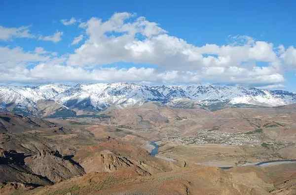
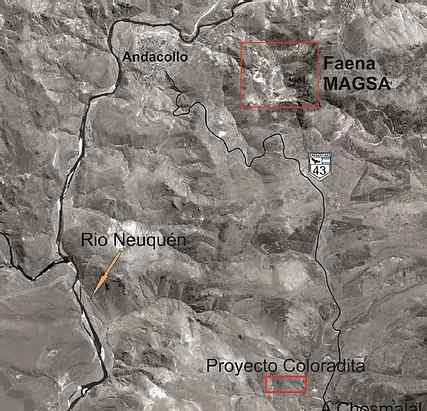 The 12 has Project is located at 14 km of Andacollo Locality, Neuquén Project, going from Provincial Route Nº 43 toward Chosmalal, accessing via La Primavera Post. The Project studied is comprehended in Gauss Kruger System, Datum Campo Hinchauspe, in the following coordenates:
X = 2354913.23 Y = 5876257.80
X = 2354913.73 Y = 5876068.83
X = 2355510.63 Y = 5876068.31
X = 2355510.14 Y = 5876257.28
DRILLING CAMPAGNE
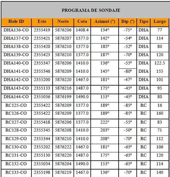
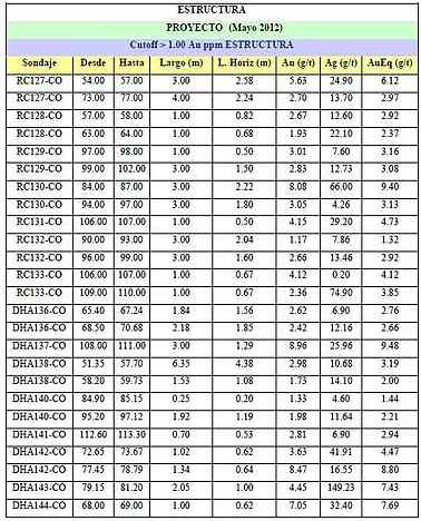
The drilling campaign was made to stablish continuity in structure depth interpreted in surface with the possibility of realizing a calculation of resources from Project. (Ser Table 1)
The drilling program was taken by the firm Servicios Mineros Lozano and Ecominera, It was supervised by personnel of MAGSA.
A total of 1866.50 meters of drilling was made, 944.50 m of diamantine were made by Ecominera and 922 m of reversed air were drilled by Lozano, itd on November and finished in January.
DRILLING PROGRAM
El detailed surface sampling realized by channels and trench revealed relevant mineralization values as 1.80 @ 11.98AuEq, 4.15 @ 16.33AuEq, and 1.25 @ 10.92AuEq, reaching a total of 60 samples mainly over structures and samples of contact box rock.
DRILLINGS
During drilling campaign 2011-2012 realized by MAGSA Explorations a total of 1866.50 meters were drilled, 944.50 m of diamantine were realized by Ecominera and 922 m of reverse air were drilled by Lozano,ng in November, and finishing in January. The results obtained from interceptions of the structure in depth showed an average thickness of 2.00 meters with an average law of 4.00 AuEq, showing extreme values in different point of the structure as, 3.00 m @ 9.48AuEq, 3.00m @ 9.40AuEq, 1.34m @ 8.80AuEq, 1.00m @ 7.69AuEq and 3.00m @ 6.12AuEq.
DISSEMINATED
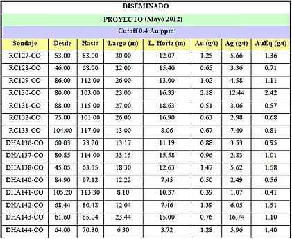
Through chemical analysis from drilling samples it could be determined a zone of disseminated mineralization located in the rock of the box, formed by porphyrites basic and intermediate with pervasive prophylactical alteration intercepting areas with values as: 23.00m @ 2.42AuEq, 18.30m @ 1.58AuEq, 23.44m @ 1.10AuEq and 33.15m @ 1.01AuEq.
MINERALIZED STRUCTURE
The potential estimation of resources deduced is 34,043 Oz Au,
with a tonnage of 131,846 Tn and a cut law of 5 gr/Tn of AuEq.
GEOLOGY OF THE PROJECT
LITHOLOGY
The area for the study is a zone with a soft folding with soft geological dips that varies between 15º to 30º to SW and NE, with no important fails that provokes a structural control to the area. Looking regional geology rocks. Going to the North of the Project acid exponents are manifested, represented by rhyolitic limestones, acid crystal limestones with high % of quartz, breach, and ignimbrites. Project area are characterized for a homogenic lithology, with no big change. In zone of prospection and exploration a series of volcanic rocks, basic and intermediate, are shown and cover all sector. The series presents a path 117º and a dip of 11-20º SSW.
ALTERATION OF THE PROJECT
- • The rock in the structure box shows an alteration level that varies in special disposition, not the alteration type. The propylitic alteration is predominant in all the sector.
- It is present in most of the rock in the box, not all values of mineralization are relevant, but they are related to mineralization.
- In sectors that circles the structure area occurrence gets higher showing in little veins made of chlorite + epidote + quartz + carbonates, dissemination of chlorite and epidote, and the presence of “punctures” are present in the structure being s, being it almost at all. Oxidation manifests with the presence of abundant limonite and y hematite, in a minor proportion goethite, and the pervasive argilization with presence of yellow-grey plastic clay. Both alterations are present in the surface.
- Silicification is selective and it is in a low grade in the structure and in the box rock.
MINERALIZATION
The mineralization in the Project manifests in two ways, vein-fault type and disseminated type:
Mineralization vein-fault type
It is manifested as a lining of 1-1.5 depth meters. The results obtained from interceptions in the deep structure showed an average thickness of 2.00 meters with an average law of 4.00 AuEq, showing extreme values in different points of the structure.
Mineralization disseminated
It manifests in basic-intermediate porphyrites with low apparition of little banks of thin sandstone, with stratification presence. It presents a thickness between 20-25 meters approximately. Dissemination of sulfide in porphyrites or in the small lents of sandstone are not shown. The analysis shown interesting values as: 23.00m @ 2.42AuEq, 18.30m @ 1.58AuEq, 23.44m @ 1.10AuEq and 33.15m @ 1.01AuEq.
ECONOMICAL GEOLOGY
Vein-fault
The structure is a lining with intense work of pirquineros, that can be recognized in the surface and in satellite images. A lining cutting obliquely the hill can be seen. The East tunnel is at 1325 meters and the West tunnel is at 1420 meters, reaching up to 1460 meters. The general path of the structure is N 85˚-90˚, it is constant in all the road because there is no fail and/or slipping that alters it. The inclination in the surface is 67˚-70˚SSW, on depth it verticalize and in some sectors it seems to invert its direction of dip a few grades. In the deep the structure is formed by two mineralized branches. The total flushing long is 600 mts.
Disseminated
The dissemination of vein-fault is located forming an “halo” surrounding the structure, in depth it manifests between the two branches of the structure and surrounding it. It is related with the levels of porphyrites basic-intermediate with strong porphyritic alteration, in zones totally pervasive forming punctures or hosts totally composed of epidote-chlorite. As it is subject to mineralization by vein, it path is mainly identical to the one in the structure east-west. Because drilling were directed to the structure and were no very deep, the base of mineralization is unknown. Because of what has been observed, the dip of the dissemination will match with the one of the basic porphyrite layers, 11˚-20˚ to SSW and parallel paths to N117º-N120º. Morphology and internal structure of the body.
Vein Fault
The lining is composed by a vein-fault that in the surface is manifested by a leached of fault approximately 0.80-1.00 meter, joined for a band of sulfides with quart and clay veins with a thickness of 0.50-0.70 meters, with a total thickness of 1.20-1.50 meters. In some drilling shown it could be observed the structure composed by the quartz vein with a gray percent of blende, up to a 40 %, poor galena (<5%) and pyrite (<5%). The sulface is random, being intercepted only in three 3 drillings being with the hydrothermal breaching and small venting of pure quart.
QUALITY CONTROL
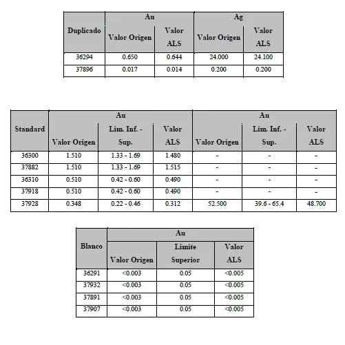 To take control over the results delivered by the Lab of Chemical Analysis ALS and to grant reliability of the law-values obtained, a Quality Control was made. It was made in the following manner:
In a total of 75 samples there are at least:
• 3 White
• 1 Thick Duplicate (#10)
• 1 Fine Duplicate (#200)
• 4 Standards
The selection in type Standard was made with the previous knowledge of the zone to test, having into account values has to be similar to the evaluated ones. For the white one it was used crystalline quartz certified by external lab.
RECOMMENDATIONS
Realizar muestreo mas denso de las rocas de caja de zonas aledañas.
Verificar continuidad de la mina hacia el oeste.
Realización de sondajes en zonas no exploradas y de mayor profundidad a fin de densificar la información y ampliar la zona de mineralización diseminada.
CONCLUSIONS
Base on the obtained information from the prospection and exploration campaign the conclusion is the following:
• The lining is a structure vein-fault type, in its surface it has a path with direction N 85-90 and an inclination of 67 SSW, in depth with homogenic direction to the surface but it can be seen its verticalization.
• Its dept is between 1.50 and 2.00 meters, in depth it changes.
• Mineralization that can be seen according to chemical analysis is changeable. This can be seen by values over 30 ppm Au, only present in isolated points.
• The lining goes through a formation constituted by basic-intermediate porphyrites that contains in areas mineralized veins parallel to the main structure that are not continues.